Farm Pin Crop Detection Challenge
'%3e%3cpath fill='%23001489' d='M0 0v6h9V0z'/%3e%3cpath fill='%23e03c31' d='M0 0v3h9V0z'/%3e%3cg stroke='%23fff' stroke-width='2'%3e%3cpath id='d' d='m0 0 4.5 3L0 6m4.5-3H9'/%3e%3cuse xlink:href='%23b' stroke='%23ffb81c' clip-path='url(%23c)'/%3e%3c/g%3e%3cuse xlink:href='%23d' fill='none' stroke='%23007749' stroke-width='1.2'/%3e%3c/g%3e%3c/svg%3e)

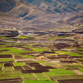
Forgot to post this when I did it, but I had fun trying out this contest without touching the provided Sentinel Imagery. Instead, I used Google Earth Engine to access some landsat images and sample them without needing to download any big files. There is no reason this couldn't be done with Sentinel Imagery (also available in GEE) but this was mainly just a proof of concept. I wrote up my experiments in two quick blog posts:
Initial post: https://datasciencecastnet.home.blog/2019/06/26/tutorial-predicting-crop-types-with-gee/
Follow-up with better modelling and submissions: https://datasciencecastnet.home.blog/2019/06/27/tutorial-improving-crop-type-predictions/
This approach scores ~1.41 despite only using a few low-quality 30m resolution images. A fun PoC of what's doable without much effort (and with terrible internet). I hope someone finds it interesting!
Thanks for sharing this, I'm definitly going to have a read when I get a chance. I wanted to attempt this challenge but have no experience with working with this sort of data and was looking for some sort of tutorial to help me get started.
Cheers!