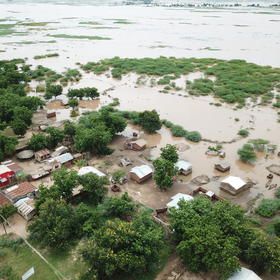
UNICEF Arm 2030 Vision #1: Flood Prediction in Malawi
'/%3e%3c/g%3e%3cuse xlink:href='%23b' transform='rotate(10)'/%3e%3c/g%3e%3cuse xlink:href='%23c' transform='rotate(20)'/%3e%3c/g%3e%3cuse xlink:href='%23d' transform='rotate(40)'/%3e%3c/g%3e%3cuse xlink:href='%23e' transform='rotate(-80)'/%3e%3c/g%3e%3cpath d='M-225-21.5h450v7.5h-450z'/%3e%3cpath fill='%23339E35' d='M-225 86h450v100h-450z'/%3e%3c/svg%3e)
Helping Malawi
$10 000 USD
Completed (~6 years ago)
Forecast
1997 joined
484 active
Start
Dec 02, 19
Close
May 17, 20
Reveal
May 17, 20

Extracting Data from Google Earth Engine
Data · 9 May 2020, 00:24 · edited 1 minute later · 4
I made a video that can help you add dataset created from google earth engine to your train data using QGIS . This video can be helpfull to those who are not conversant in using Geospatial library in Python or R.
Thanks WaReal
This is great.. Thanks a lot
The video also entails recreating the rectangle(0.01 degree) from which the coordinates(X, Y) were created. May the best Model Win!!
Thanks for the video WaReal.