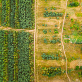
AgriFieldNet India Challenge
'%3e%3ccircle r='20' fill='%23008'/%3e%3ccircle r='17.5' fill='%23fff'/%3e%3ccircle r='3.5' fill='%23008'/%3e%3cg id='d'%3e%3cg id='c'%3e%3cg id='b'%3e%3cg id='a' fill='%23008'%3e%3ccircle r='.875' transform='rotate(7.5 -8.75 133.5)'/%3e%3cpath d='M0 17.5.6 7 0 2l-.6 5L0 17.5z'/%3e%3c/g%3e%3cuse xlink:href='%23a' transform='rotate(15)'/%3e%3c/g%3e%3cuse xlink:href='%23b' transform='rotate(30)'/%3e%3c/g%3e%3cuse xlink:href='%23c' transform='rotate(60)'/%3e%3c/g%3e%3cuse xlink:href='%23d' transform='rotate(120)'/%3e%3cuse xlink:href='%23d' transform='rotate(-120)'/%3e%3c/g%3e%3c/svg%3e)
Helping India
$10 000 USD
Completed (over 3 years ago)
Classification
Earth Observation
793 joined
179 active
Start
Sep 05, 22
Close
Oct 31, 22
Reveal
Oct 31, 22

Domain Understanding
Help · 6 Oct 2022, 10:13 · 2
Most of us are new to this kind of data(or maybe I alone) . Who has understood the dataset so that she/he can explain it to us?
Hello Koleshjr,
Data provided in the competition are satellite images taken from the Sentinel-2 satellite. They are like typical images, but instead of having only 3 bands(RGB), they have 12 bands(detail). Just like RGB, these bands capture different information about the data depending on how the objects depicted in the image interact with the light.
You can refer to this documentation for more details about how different bands provide different information and how remote sensing(in our case, satellite imagery) works and captures the data.
Thank you 🤝