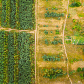
AgriFieldNet India Challenge
'%3e%3ccircle r='20' fill='%23008'/%3e%3ccircle r='17.5' fill='%23fff'/%3e%3ccircle r='3.5' fill='%23008'/%3e%3cg id='d'%3e%3cg id='c'%3e%3cg id='b'%3e%3cg id='a' fill='%23008'%3e%3ccircle r='.875' transform='rotate(7.5 -8.75 133.5)'/%3e%3cpath d='M0 17.5.6 7 0 2l-.6 5L0 17.5z'/%3e%3c/g%3e%3cuse xlink:href='%23a' transform='rotate(15)'/%3e%3c/g%3e%3cuse xlink:href='%23b' transform='rotate(30)'/%3e%3c/g%3e%3cuse xlink:href='%23c' transform='rotate(60)'/%3e%3c/g%3e%3cuse xlink:href='%23d' transform='rotate(120)'/%3e%3cuse xlink:href='%23d' transform='rotate(-120)'/%3e%3c/g%3e%3c/svg%3e)
Helping India
$10 000 USD
Completed (over 3 years ago)
Classification
Earth Observation
793 joined
179 active
Start
Sep 05, 22
Close
Oct 31, 22
Reveal
Oct 31, 22

Is using external data allowed?
Data · 30 Oct 2022, 04:55 · 2
Since the data range is provided - Jan 2022 to Apr 2022, and the GeoJSONs for each 256x256 source tiles are also provided, I wanted to know if personally downloading data for multiple timestamps for different satellite sources is allowed or we are restricted to using whatever data is already provided.
Good try, that would help but external data is not allowed:
"You may use only the datasets provided for this competition."
https://zindi.africa/competitions/agrifieldnet-india-challenge , Rules, Datasets and packages
Ah thanks I think I missed that line 😅