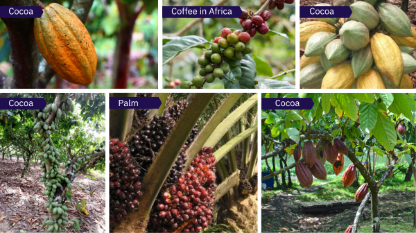
Understanding and accurately predicting agricultural output is crucial for sustainable development, economic planning, and food security. However, comprehensive and up-to-date data on crop production in many African countries is missing and hard to collect. Access to reliable data on crops such as coffee, cocoa, palm oil, and forests will help businesses and governments make better decisions and support local farmers.
The primary objective of this data collection challenge is to gather extensive and high-quality data on key crops and forestry across select African countries. Specifically, participants will focus on collecting data related to coffee, cocoa, palm oil, and forest cover in the following countries:
Participants will only be able to collect data from the crops and forests in their respective countries. This limitation encourages collaboration, and ensures that data collection efforts are targeted and relevant to the local context.
The data collected through this competition will serve as valuable input for developing machine learning models and other analytical tools aimed at predicting crop yields, assessing environmental impact, and guiding land-use planning. Further, all data collected and will be published under an open access license, with early access given to the top 200 participants of this challenge. The goal is to ensure that this dataset is availabe for future projects that support local farmers in partnership with Amini.
Ultimately, the data collected will contribute to more informed decision-making processes, leading to improved agricultural practices, sustainable resource management, and enhanced food security across the participating nations.
About Amini (amini.ai)
Amini, headquartered in Nairobi, is a deep-tech company harnessing space technology and artificial intelligence to address the scarcity of environmental data in Africa. We provide a resilient and secured environmental data infrastructure tailored to empower various stakeholders within the data ecosystem for climate action initiatives.
In order to compete in this challenge, you will need to install the Uwazi App on your phone. Download the app HERE.
NB: You need to sign up with the same email address you used to sign up to Zindi. This will allow us to update the leaderboard with the number of data points you collected.
To learn more about how the app works, watch the videos:
All data collected using the Uwazi data collection app will be validated internally to ensure it meets Amini’s quality standards (read more in the Data Quality section). Once a week (on a Tuesday), the Zindi leaderboard will update to show the total score per person.
If your data collection does not meet the requirements in Data Quality, then you will receive no points for that data collection.
Score = (Data Quantity + Data Quality + Frequency) x Rural Modifier
Your total number of points will be shown on the leaderboard, and will update once per week.
Once the competition has closed, your total number of points might change, as Zindi and Amini will conduct a final data review of all submissions before awarding prizes.
When collecting data, it is important to have a common understanding of the different terms used so that all data collectors are collecting to the same standard. This ensures that the resulting dataset is of high quality and is fit for purpose. Below we have given examples and definitions to help. If you are uncertain or have concerns, please raise them on the discussion board.
For this data collection challenge, we are only collecting data on areas that are greater than or equal to 0.5 acres. This is a 2000 square meter area, or a square of 45 meters per side.
Each side of the crop needs to be at least 45 meters long, i.e it can be larger than 45m. One meter is the same as one long stride, so if you would like to get an estimate of the length of a crop you can pace out 45 big steps.
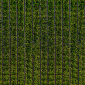
Many farms plant different crops in one area. For this competition we are only looking for crops where 1 crop takes up an entire 0.5 acres (45m x 45m area).
Geo-polygon refers to a polygonal area or shape on the Earth's surface, in this context used in mapping. This might be employed to define boundaries, study land use patterns, or represent geographic features.
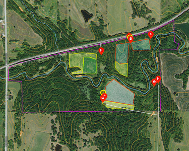
Often farmers and neighbors plant close to each other, and it is hard to determine where one crop/farm starts and ends.
Your best option is to confirm with the farmer. Alternatively, here are some directions to help you:
For the purposes of this project, a forest is defined as
In the Uwazi data collection app, you must describe what you are seeing in the image. You need to use a minimum of 10 words that make sense.
Here are some examples of descriptive words you can use:
Arid, Brown, Dry, Barren, Green, Lush, Fruitful, in season, out of season, drought, pest, damaged, harvested, seeding.
Rural areas are geographic regions characterised by low population density and limited infrastructure development compared to urban areas. These areas are typically dominated by agricultural activities, natural landscapes, fishing, forestry and small communities. In this challenge, we consider rural areas to be anything more than 50kms from an urban centre.
An urban area refers to a region characterized by high population density and significant infrastructure development, such as buildings, roads, transportation networks, and utilities. In this challenge, we consider rural areas to be anything less than 50kms from an urban centre.
In any data collection project, informing people involved in the data collection and asking them for consent before collecting data is an important part of the process. Informed consent means that the farmer understands what they are agreeing to. We encourage you to ask for the landowner’s consent before collecting data about their land (especially when taking photographs).
Below is a script you can use to ask the farmer if you can collect data from their farm:
Hello, my name is [Name]. I am collecting data for a competition hosted by Amini. Amini is running the Uwazi Citizen Science Challenge to collect data on farms in Africa, contributing to the future of AI on the continent.
Would you like me to explain more about the competition?
A photo of your crop will be captured, it will be pinpointed on a map, and details of its contents will be noted. This data will be added to a public database where it can be accessed for research and development, government policies, business, or other purposes.
No personal data including your name, phone number, address or any other information that may identify you as an individual will be published.
Do I have your voluntary consent to collect this data? If you voluntarily give your consent, then you are consenting for Amini and anyone accessing the public database to receive information about your farm. Your information will be held in strict confidentiality and will be used only for the purposes of this competition. The results will be reported in aggregate form only, and cannot be used to identify your farm individually.
If you'd like to learn more about how your data will be used or have any questions, you can visit this link (https://zindi.africa/competitions/amini-crop-data-citizen-science-challenge). Let's proceed with taking the picture and mapping your crop.
Bonjour, je m’appelle [Nom]. Je collecte des données enviromentales pour une competition organisé par Amini. Amini organise l’Amini “Crop Data Citizen Science Challenge” pour collecter des données sur les exploitations agricoles en Afrique, contribuant ainsi à l’avenir de l’Intelligence Artificielle sur le continent.
Voulez-vous que je vous en dise plus sur la compétition ?
Une photo de votre récolte/culture sera capturée, elle sera localisée sur une carte et les détails de son contenu seront notés. Ces données seront ajoutées à une base de données publique où elles pourront être consultées à des fins de recherche et développement agricole, de politiques gouvernementales, commerciales ou autres.
Aucune information personnelle, comprenant mais ne se limitant pas à votre nom, numéro de téléphone, adresse, ou toute autre donnée permettant de vous identifier en tant qu'individu, ne sera rendue publique.
Souhaitez-vous donner volontairement votre consentement pour la collecte de ces données? En donnant volontairement votre consentement, vous acceptez que Amini et toute personne ayant accès à la base de données publique reçoivent des informations concernant votre exploitation agricole. Vos données seront traitées de manière strictement confidentielle et ne seront utilisées que dans le cadre de cette compétition. Les résultats seront rapportés uniquement de manière agrégée et ne pourront pas être identifiés individuellement.
Si vous souhaitez en savoir plus sur l'utilisation de vos données ou si vous avez des questions, vous pouvez consulter ce lien (https://zindi.africa/competitions/amini-crop-data-citizen-science-challenge).
Procédons maintenant à la prise de la photo et a la géolocalisation de votre récolte/culture.
Competition closes on 9 June 2024.
Final submissions must be received by 11:59 PM GMT.
Final leaderboard will be revealed on Tuesday, 11 June 2024.
We reserve the right to update the contest timeline if necessary.
This challenge is open to participants from Kenya, Ethiopia, Uganda, Tanzania, Rwanda, Ivory Coast, Ghana and Nigeria.
You may participate in this competition only as an individual.
Multiple accounts per user are not permitted, and neither is collaboration or membership across multiple teams. Individuals and their submissions originating from multiple accounts will be immediately disqualified from the platform.
If two solutions earn identical scores on the leaderboard, the tiebreaker will be the date and time in which the submission was made (the earlier solution will win).
The winners will be paid via bank transfer, PayPal if payment is less than or equivalent to $100, or other international money transfer platform. International transfer fees will be deducted from the total prize amount, unless the prize money is under $500, in which case the international transfer fees will be covered by Zindi. In all cases, the winners are responsible for any other fees applied by their own bank or other institution for receiving the prize money. All taxes imposed on prizes are the sole responsibility of the winners. The top winners or team leaders will be required to present Zindi with proof of identification, proof of residence and a letter from your bank confirming your banking details. Winners will be paid in USD or the currency of the competition. If your account cannot receive US Dollars or the currency of the competition then your bank will need to provide proof of this and Zindi will try to accommodate this.
Please note that due to the ongoing Russia-Ukraine conflict, we are not currently able to make prize payments to winners located in Russia. We apologise for any inconvenience that may cause, and will handle any issues that arise on a case-by-case basis.
Payment will be made after data review and sealing the leaderboard.
You acknowledge and agree that Zindi may, without any obligation to do so, remove or disqualify an individual, team, or account if Zindi believes that such individual, team, or account is in violation of these rules. Entry into this competition constitutes your acceptance of these official competition rules.
Zindi is committed to providing solutions of value to our clients and partners. To this end, we reserve the right to disqualify your submission on the grounds of usability or value. This includes but is not limited to the use of data leaks or any other practices that we deem to compromise the inherent value of your solution.
Zindi also reserves the right to disqualify you and/or your submissions from any competition if we believe that you violated the rules or violated the spirit of the competition or the platform in any other way. The disqualifications are irrespective of your position on the leaderboard and completely at the discretion of Zindi.
Please refer to the FAQs and Terms of Use for additional rules that may apply to this competition. We reserve the right to update these rules at any time.
Join the largest network for
data scientists and AI builders