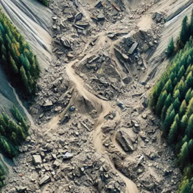
Classification for Landslide Detection
The optical imagery is sourced from Sentinel-2, specifically from the MultiSpectral Instrument (MSI) at Level-2A, which provides Red, Green, Blue, and Near Infrared (NIR) bands with a resolution of 10 meters.
Complementing this is radar imagery from Sentinel-1, which includes the VV and VH polarization bands (Vertical-Vertical and Vertical-Horizontal) at a similar resolution of 10 meters. The dataset includes post-event radar imagery, which captures backscatter intensity changes on the ground, and change detection bands calculated by subtracting pre-event from post-event data. The radar data is particularly useful as it can penetrate cloud cover, providing a consistent view of ground surface changes regardless of weather conditions.
Together, these optical and radar datasets offer a multi-faceted perspective, combining visual and SAR data to detect ground disturbances that often accompany landslides. Additionally, the dataset is based on landslide inventories from various earthquake-triggered landslide events.
Thank you to Lorenzo Nava, Postdoctoral Research Associate in Multihazard Remote Sensing, Departments of Earth Sciences & Geography, University of Cambridge, Cambridge Complex and Multihazard Research Group (CoMHaz) for the data preparation and starter notebook.
Join the largest network for
data scientists and AI builders