
GeoAI Challenge Estimating Soil Parameters from Hyperspectral Images by ITU
The objective of this challenge is to automate the process of estimating the soil parameters, specifically, potassium (K), phosphorus pentoxide (P2O5), magnesium (Mg) and pH, through extracting them from the airborne hyperspectral images captured over agricultural areas in Poland (the exact locations are not revealed). To make the solution applicable in real-life use cases, all the parameters should be estimated as precisely as possible.
The dataset comprises 2886 patches in total (2 m GSD), of which 1732 patches for training and 1154 patches for testing. The patch size varies (depending on agricultural parcels) and is on average around 60x60 pixels. Each patch contains 150 contiguous hyperspectral bands (462-942 nm, with a spectral resolution of 3.2 nm), which reflects the spectral range of the hyperspectral imaging sensor deployed on-board Intuition-1.
The participants are given a training set of 1732 training examples. The examples are hyperspectral image patches with the corresponding ground-truth information. Each masked patch corresponds to a field of interest, as presented in Fig. 1. Ground truth are the soil parameters obtained for the soil samples collected for each field of interest in the process of laboratory analysis, and is represented by a 4-value vector.
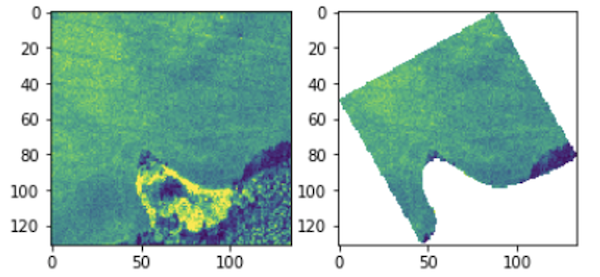
Fig. 1: The participants are given the masked hyperspectral image patches corresponding to the fields of interest (one masked patch is a single field), and should estimate the four soil parameters based on the available image data.
Datasets available for download
- Train dataset: https://s3.waw2-1.cloudferro.com/swift/v1/AUTH_afccea586afd4ef3bb11fe37dd1ddfbf/Download_KPLabs_Chellenge/train_data.zip
- Test dataset: https://s3.waw2-1.cloudferro.com/swift/v1/AUTH_afccea586afd4ef3bb11fe37dd1ddfbf/Download_KPLabs_Chellenge/test_data.zip
- Starter Toolkit: https://github.com/AI4EO/kp-labs-seeing-beyond-visible-challenge