GeoAI Hack 2022 Crop Type Classification Challenge by IEEE Sup'Com GRSS & AGEOS

Helping Tunisia
1 800 TND
Completed (~4 years ago)
Classification
Earth Observation
130 joined
77 active
Start
Apr 22, 22
Close
Apr 23, 22
Reveal
Apr 23, 22
About
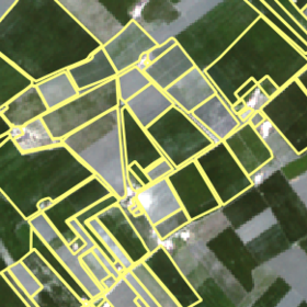
The dataset for this competition is generated through a time-series of satellite imagery and labels for crop type that have been collected through ground survey. Parcels were digitized from VHR imagery. Labels are derived from the survey conducted by the AGEOS Team. Satellite data including multispectral Sentinel-2 are then matched with corresponding labels.
The features are under the format timestepT_BAND_AGG where:
- T is the timestep number that ranges from 1 to 24 and has been shuffled. The mapping corresponds to {1: '2021-04-28', 2: '2021-04-25', 3: '2021-03-06', 4: '2021-02-19', 5: '2021-02-12', 6: '2021-01-23', 7: '2021-01-15', 8: '2020-12-31', 9: '2020-12-29', 10: '2020-12-24', 11: '2020-12-16', 12: '2020-11-26', 13: '2020-11-14', 14: '2020-11-09', 15: '2021-03-29', 16: '2021-03-11', 17: '2021-02-27', 18: '2021-02-17', 19: '2021-02-09', 20: '2021-01-30', 21: '2021-01-20', 22: '2021-01-08', 23: '2021-01-13', 24: '2020-12-14'}
- BAND is the Sentinel-2 Spectral band it includes "B02", "B03", "B04", "B05", "B06", "B07", "B08", "B8A", "B11", "B12". For more reference check out this link.
- AGG is the aggregation that was applied on the pixels values per field. It includes "mean", "median", "std", "max", "min".
The Target is the Crop Type of the field. It includes: 'olive+cereals', 'plowing_and_sowing', 'olive', 'arable_soil', 'olive+arbo', 'orchards', 'olive+crops', 'wheat', 'greenhouses', 'vegetable_and_flower', 'forage_crop', 'cereals', 'mixed_crops'.
Files
Description
Files
This is the dataset on which you will apply your model to, it resembles Train.csv but without the target column.
This shows the submission format for this competition, with the ‘ID’ column mirroring that of Test.csv and the ‘Label’ column containing your predictions. The order of the rows does not matter. The rows of the columns do matter.
Join the largest network for
data scientists and AI builders
Status
© Zindi 2026